-
Services
-
expand_more
Back
Services
-
-
expand_more
Back
Rates & Property
- Setting the Rates
- New Wastewater Rates for Cardrona
- Revaluation and how it affects rates
- Rates Dates & Payment Options
- Changing your details
- Property Information Search
- Online Rates Payments
- Rates Rebates, Remission & Postponement
- Short-Term Visitor Accommodation
- Other Information
- Rates FAQs
-
-
expand_more
Back
Rubbish & Recycling
- How we recycle in the Queenstown Lakes District
- Cut your waste
- Commercial Services
- Rubbish & Recycling Collection
- Recycling Centres
- Transfer Stations
- Solid Waste Assessment
- Waste Minimisation Community Fund
- Waste Minimisation for Businesses
- Zero Waste Events
- Other Waste
- A-Z Directory Feedback
-
-
expand_more
Back
Resource Consents
- Application forms and fees
- Current resource consents
- Development contributions
- Duty Planner
- eDocs
- Engineering acceptance
- Exemptions
- FAQs
- Find your zone using GIS
- How to use the District Plan to know the rules
- Land developments and subdivisions
- National Policy Statements and National Environmental Standards
- Notified resource consents
- Practice notes and guidance
- Pre-application meetings
- Resource consent process
-
-
expand_more
Back
Alcohol Licensing
- Alcohol Public Notices
- Find the right alcohol licence and apply
- Rugby World Cup Information
- Alcohol licence fee calculator
- Renew and/or vary your alcohol licence
- Manager's certificates
- Legal requirements for licence holders
- District Licensing Committee decisions
- ARLA annual report
- Alcohol-Free Areas In Public Places
- Have your say on alcohol licence applications
- All alcohol licensing forms
-
-
Do It Online
-
expand_more
Back
Do It Online
-
-
expand_more
Back
Registrations
- Register your Dog
- Register for a transfer or refund of dog registration fee
- Renewal for Hairdressers, Campgrounds, and Offensive Trade Registrations
- Activities in a Public Place - Application Form
- Register as a Homestay
- Register as Residential Visitor Accommodation
- Register for our public notification list
- Register to speak at Public Forum
- Register for Kerbside Collection Services
- No Spray Register
-
Community
Community
Ngā Hapori
- Summerdaze
- Manaaki
- Community Connect
- Welcoming Communities
- Arts, Culture and Heritage
- Citizenship Ceremonies
- Community Associations and Groups
- Community Funding
- Community Research
- Community Wellbeing
- Economic Development
- Emergency Management
- Energy Saving Tips
- Event Planning and Venues
- Māori Community
- Managing the risk of wildfire
- Population and Demand
- Tuia Programme
- Venue Hire
- Winterdaze

Winter Road Reports
Keep up to date with our road conditions throughout the colder months.
-
Recreation
Recreation
Kā mahi a te rēhia
- Queenstown Events Centre
- Wānaka Recreation Centre
- Paetara Aspiring Central
- Swim
- Learn to Swim
- Golf
- Kids' Recreation
- Sport & Rec Venues and Contacts
- Courts and Fields
- Memberships - Join Today
- Join the Sport & Rec Team
- Responsible Camping in the Queenstown Lakes District
- Parks and Walkways
- Lakes and Boating
- Mountain Biking
- Horse Riding
- Splash Café
- Wallis Physiotherapy
- Alpine Physiotherapy
- Physiotherapy
- Playgrounds
- School Holiday Programmes
- Gym & Group Fitness

Hip Hop Fit
Learn to dance and get fit!
-
Your Council
Your Council
Te Kaunihera ā-rohe

Careers
Check out what positions we are currently recruiting for.
-
expand_more
Back
Your Council
-
-
expand_more
Back
Council Documents
- Ten Year Plan (LTP)
- Agendas & Minutes
- Annual Plans
- Annual Reports
- Asset Management Plans
- Awarded Council Contracts
- Bylaws
- Capex Quarterly Update
- Monthly Reports
- National Policy Statement - Urban Development 2020 (NPS-UD)
- Policies
- Pre-election reports
- Queenstown Lakes Spatial Plan
- Reserve Management Plans
- Section 10A Reports
- Small Community Plans
- Strategies and Publications
- Submissions from QLDC
-
-
expand_more
Back
District Plan
- Operative District Plan
- Proposed District Plan
- ePlans
- National Policy Statement-Urban Development (District Plan Amendments)
- Urban Intensification Variation
- District Plan maps
- A Guide to Plan Changes
- Inclusionary Housing Variation
- Landscape Schedules
- Te Pūtahi Ladies Mile Variation

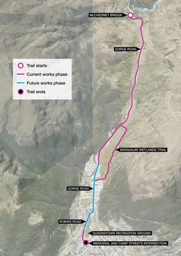
Arthurs Point to Queenstown shared path
A shared pathway linking McChesney Bridge, Arthurs Point and Queenstown is now complete. The pathway makes it safer and easier for people to walk, cycle or scoot to town or back.
Quick links
About the project
The Arthurs Point to Queenstown route was identified as one of eight priority trails for the Whakatipu Active Travel Network: an integrated network of trails for walking and cycling that connects to public transport, providing a genuine alternative to getting around by car.
The route recently received funding through the Transport Choices package. This is part of the Waka Kotahi Climate Emergency Response Fund (CERF) programme, which aims to demonstrate what’s possible for communities nationwide by quickly providing people with healthier, more affordable, and safer transport choices that are good for us, and for the environment.
The routes starts at McChesney Bridge and follows Gorge Road towards Queenstown, traveling through rural and urban areas. It links in to the Matakauri wetland trail then recommences along Robins Road, adjacent to the Recreation Ground, finishing at the intersection of Memorial and Camp Street.
The work includes:
-
upgrading the existing rural trail to an asphalt and chipseal surface
-
drainage and surfacing upgrades to the Matakauri wetlands trail (note the trail will remain unsealed in this location)
-
sealing the road shoulder adjacent to the Matakauri wetland trail
-
creating a wider shared path along Robins Road, between the Recreation Ground and the intersection of Memorial and Camp Street.
-
retaining walls, safe crossing points and associated line marking.
Route map
Design drawings
We've provided the detailed design drawings below:
Stay up-to-date
Sign up to our newsletter Scuttlebutt and stay up-to-date with the latest news, events & information in the Queenstown Lakes District.