-
Services
-
expand_more
Back
Services
-
-
expand_more
Back
Rates & Property
- Setting the Rates
- New Wastewater Rates for Cardrona
- Revaluation and how it affects rates
- Rates Dates & Payment Options
- Changing your details
- Property Information Search
- Online Rates Payments
- Rates Rebates, Remission & Postponement
- Short-Term Visitor Accommodation
- Other Information
- Rates FAQs
-
-
expand_more
Back
Rubbish & Recycling
- How we recycle in the Queenstown Lakes District
- Cut your waste
- Commercial Services
- Rubbish & Recycling Collection
- Recycling Centres
- Transfer Stations
- Solid Waste Assessment
- Waste Minimisation Community Fund
- Waste Minimisation for Businesses
- Zero Waste Events
- Green and food waste
- Construction and demolition waste
-
-
expand_more
Back
Resource Consents
- Application forms and fees
- Current resource consents
- Development contributions
- Duty Planner
- eDocs
- Engineering acceptance
- Exemptions
- FAQs
- Find your zone using GIS
- How to use the District Plan to know the rules
- Land developments and subdivisions
- National Policy Statements and National Environmental Standards
- Notified resource consents
- Practice notes and guidance
- Pre-application meetings
- Resource consent process
-
-
expand_more
Back
Alcohol Licensing
- Alcohol Public Notices
- Find the right alcohol licence and apply
- Rugby World Cup Information
- Alcohol licence fee calculator
- Renew and/or vary your alcohol licence
- Manager's certificates
- Legal requirements for licence holders
- District Licensing Committee decisions
- ARLA annual report
- Alcohol-Free Areas In Public Places
- Have your say on alcohol licence applications
- All alcohol licensing forms
-
-
Do It Online
-
expand_more
Back
Do It Online
-
-
expand_more
Back
Registrations
- Register your Dog
- Register for a transfer or refund of dog registration fee
- Renewal for Hairdressers, Campgrounds, and Offensive Trade Registrations
- Activities in a Public Place - Application Form
- Register as a Homestay
- Register as Residential Visitor Accommodation
- Register for our public notification list
- Register to speak at Public Forum
- Register for Kerbside Collection Services
- No Spray Register
-
Community
Community
Ngā Hapori
- Winterdaze
- Manaaki
- Community Connect
- Welcoming Communities
- Arts, Culture and Heritage
- Citizenship Ceremonies
- Community Associations and Groups
- Community Funding
- Community Research
- Community Wellbeing
- Economic Development
- Emergency Management
- Energy Saving Tips
- Event Planning and Venues
- Māori Community
- Managing the risk of wildfire
- Population and Demand
- Summerdaze
- Tuia Programme
- Venue Hire

Winter Road Reports
Keep up to date with our road conditions throughout the colder months.
-
Recreation
Recreation
Kā mahi a te rēhia
- Queenstown Events Centre
- Wānaka Recreation Centre
- Paetara Aspiring Central
- Swim
- Learn to Swim
- Golf
- Kids' Recreation
- Sport & Rec Venues and Contacts
- Courts and Fields
- Memberships - Join Today
- Join the Sport & Rec Team
- Responsible Camping in the Queenstown Lakes District
- Parks and Walkways
- Lakes and Boating
- Mountain Biking
- Horse Riding
- Splash Café
- Wallis Physiotherapy
- Alpine Physiotherapy
- Physiotherapy
- Playgrounds
- School Holiday Programmes
- Mascot Search

Winter Wander
Join our walking challenge
-
Your Council
-
expand_more
Back
Your Council
-
-
expand_more
Back
Council Documents
- Long Term Plan (LTP)
- Archived Agendas & Minutes
- Annual Plans
- Annual Reports
- Asset Management Plans
- Awarded Council Contracts
- Bylaws
- Capex Quarterly Update
- Monthly Reports
- National Policy Statement - Urban Development 2020 (NPS-UD)
- Policies
- Pre-election reports
- Queenstown Lakes Spatial Plan
- Reserve Management Plans
- Section 10A Reports
- Small Community Plans
- Strategies and Publications
- Submissions from QLDC
-
-
expand_more
Back
District Plan
- Operative District Plan
- Proposed District Plan
- ePlans
- National Policy Statement-Urban Development (District Plan Amendments)
- Urban Intensification Variation
- District Plan maps
- A Guide to Plan Changes
- Inclusionary Housing Variation
- Landscape Schedules
- Upper Clutha Landscape Schedules
- Te Pūtahi Ladies Mile Variation


- Services
- Rates & Property
- Rubbish & Recycling
- Building Services
-
Resource Consents
- Application forms and fees
- Current resource consents
- Development contributions
- Duty Planner
- eDocs
- Engineering acceptance
- Exemptions
- FAQs
- Find your zone using GIS
- How to use the District Plan to know the rules
- Land developments and subdivisions
- National Policy Statements and National Environmental Standards
- Notified resource consents
- Practice notes and guidance
- Pre-application meetings
- Resource consent process
- Environmental Health
- Transport and Parking
- Alcohol Licensing
- Animal Control
- Airports
- Environment and Sustainability
- Water Services
- Cemeteries
- Services A - Z
- CCTV - Public Use
- Permits
Find your zone using GIS
The zoning of all properties within the District is shown on the Council GIS maps.
To find the zoning of the property you are interested in, put the address in the Search bar or zoom in to find its location.
Once you have found it, click on your property and this will bring up a pop-up box that provides the zoning/s that apply to your property.
You can scroll through the pages showing the relevant planning information by clicking on the arrows.

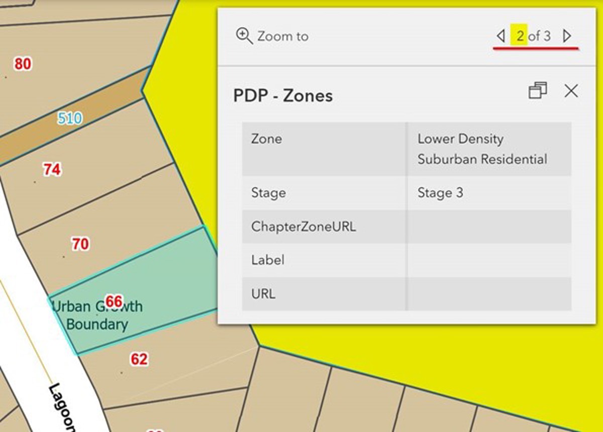
Council is currently undertaking a staged review of the District Plan, consequently the zoning of the property under both the Operative District Plan (ODP) and Proposal District Plan (PDP) may be of relevance.
There may be more than one zoning applicable to your site. For example, the property might be zoned Rural zone, but also have an area of the property which is labelled a Building Restriction Area, or a property might be zoned Lower Density Suburban Residential Zone but also have a Wahi Tupuna overlay across it. There are corresponding rules to these zonings and annotations within the District Plan.
The Council GIS mapping also provides other information which may be of relevance to your project such as natural hazards, servicing and property information.
Stay up-to-date
Sign up to our newsletters and stay up-to-date with the latest news, events & information in the Queenstown Lakes District.