


Ladies Mile Masterplan
Project Status
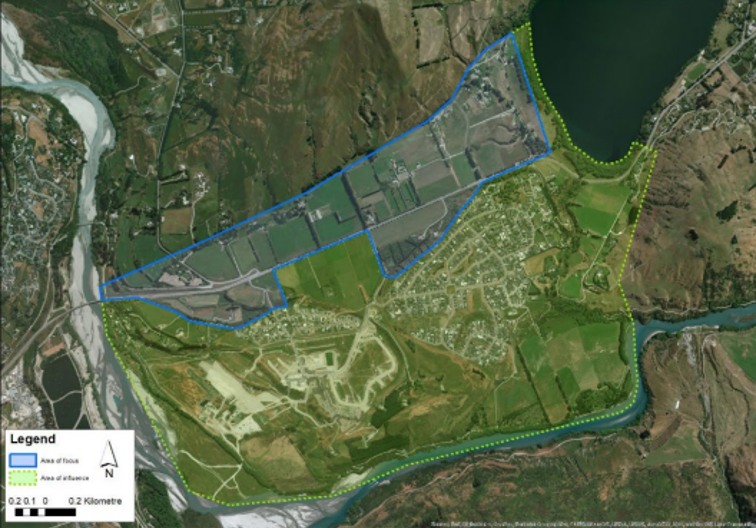
Location Map
About the project
The Ladies Mile (Te Putahi) Corridor between Shotover River (Kimi-ākau) and Lake Hayes (Te Whaka-ata a Haki-te-kura) is an area of significance for many locals, often seen as a gateway into Queenstown. It is also an area of major strategic importance for Queenstown and the wider lakes district.
-
The Masterplan will cover approximately 160 Ha. Located at a key point in the road, trail and river networks, it is largely flat, sunny and hazard free, it is close to the major employment area of Frankton and adjoins Queenstown’s largest residential area of Lake Hayes Estate, Shotover Country and the Queenstown Country Club.
The area marked in blue below is the key focus area, however there is a much wider area of influence that must be considered to ensure the Masterplan and Plan Variation delivers the best outcomes for the community.
-
Ladies Mile is a very attractive location for urban development but there are a number of challenges that need to be addressed and considered through the Masterplan and Plan Variation process:
-
It is an area of significant interest to many locals and considered by some to be the ‘rural gateway’ to Queenstown, demarking the rural and urban areas of the Wakatipu Basin.
-
Setting development back from SH6 has been a key consideration shaping development of this area to date.
-
There are capacity issues along the State Highway corridor that runs through Ladies Mile, in particular the Shotover Bridge and the Hawthorne Drive and Shotover Roundabouts.
-
Residents currently living in the area also have concerns over parking, lack of community facilities in the area.
-
There are also concerns around community severance resulting in a lack of cohesion between the three housing developments requiring residents to carry out multiple external trips to carry out everyday tasks.
-
-
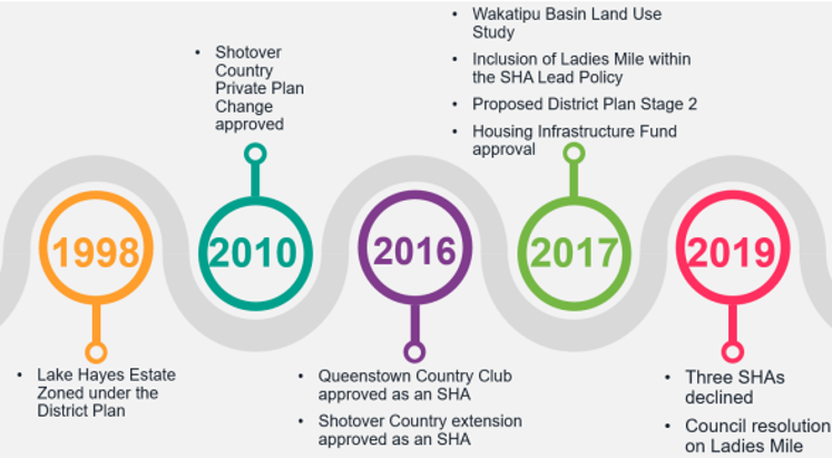
This area has seen significant change and debate over its future since the 1990s. This timeline shows some of the key decisions that have led us to this point.
There are a number of documents available that further details or provide context for the decisions outlined above
Appendices for Housing Infrastructure Fund – DBC – Ladies Mile
What's the latest?
Minister for the Environment, Penny Simmonds approved Te Pūtahi Ladies Mile Variation on Saturday 16 November 2024.
The decision by the Minister means Te Pūtahi Ladies Mile Variation will now form part of QLDC’s Proposed District Plan (PDP) and will be considered operative from Friday 6 December 2024.
Project aspirations and goals
-
-
Make the most of the opportunity to deliver highly efficient land use. This will include medium - medium/high density urban development.
-
Plan a high quality street network that promotes walking and cycling as the preferred way of getting around locally and a range of transport options for getting to Frankton and further afield.
-
Provide a framework through the masterplan process to inform decisions on a large range of potential land uses at Ladies Mile including housing, a mixed use local service centre, recreation and sports grounds, primary and secondary schools and a transport facilities.
-
Promote a strong sense of ‘place’ and ‘identity’, taking inspiration from the landscape. This should also include high levels of liveability through quality urban design.
-
Celebrate the areas pioneer and Maori history in public spaces and with distinctive built form.
-
Promote sustainable living, for example better outcomes for water quality and ecological systems, use of green technology, more transport choices that prioritise walking, cycling and public transport.
-
-
The objectives of the project are :
-
A land use solution is delivered in a timely, integrated and organised manner, avoiding individual applications
-
Increased liveability, well-being and community cohesion for existing and future residents of the Ladies Mile area
-
Improved access to and from Ladies Mile with a transport network that can deliver its functions efficiently and effectively
-
Supporting enhanced public transport and walking and cycling options through land use solutions
-
Consultation and feedback
Consultation on Te Pūtahi Ladies Mile Masterplan occurred from 2020 through to the final masterplan being adopted on 30 June 2022.
Feedback received